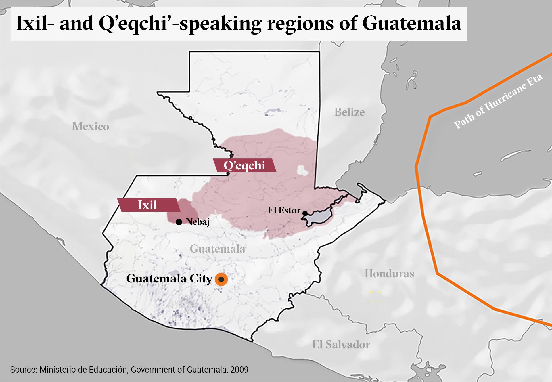
Dispossesions in the Americas

Dispossesions in the Americas

  • Inicio
  • Explorar
  • Autores
  • Sobre
  • Arte
  • Cuerpos
  • Planes de Estudio
  • Herencia Cultural
  • Mapas
  • Territorios
Volver a Explorar

Leyendo en Inglés

Mapa 2000

Ixil and Q'eqchi' speaking regions of Guatemala.

  • MINISTERIO DE EDUCACION, GOVERNMENT OF GUATEMALA.

Publicado: 2009

  • Descargar Imágen
  • Descargar Imágen
Mapa 2000

Ixil and Q'eqchi' speaking regions of Guatemala.

  • MINISTERIO DE EDUCACION, GOVERNMENT OF GUATEMALA.

Publicado: 2009

  • Descargar Imágen

Pueblos

  • IXIL
  • Q'EQCHI

Cita

Ixil and Q'eqchi' speaking regions of Guatemala. Ministerio de Educación, Government of Guatemala. 2009. In: Cuffe, Sandra (2020). "The Ixil helping hte Ixil': indigenous people in Guatemala lead their own Hurricane Eta Response" The New Humanitarian. 10 November 2020. Accessed July 29 2023. https://www.thenewhumanitarian.org/news-feature/2020/11/10/guatemala-hurricane-eta-indigenous-response

  • Descargar Imágen

Leyendo en Portugués

Mapa 2000

Ixil and Q'eqchi' speaking regions of Guatemala.

  • MINISTERIO DE EDUCACION, GOVERNMENT OF GUATEMALA.

Publicado: 2009

  • Descargar Imágen

Pueblos

  • IXIL
  • Q'EQCHI

Cita

Ixil and Q'eqchi' speaking regions of Guatemala. Ministerio de Educación, Government of Guatemala. 2009. In: Cuffe, Sandra (2020). "The Ixil helping hte Ixil': indigenous people in Guatemala lead their own Hurricane Eta Response" The New Humanitarian. 10 November 2020. Accessed July 29 2023. https://www.thenewhumanitarian.org/news-feature/2020/11/10/guatemala-hurricane-eta-indigenous-response

  • Descargar Imágen

Artículos Relacionados

Brésil et Pays des Amazones

Brésil et Pays des Amazones

Mapa 1788
Bosquejo hodométrico del expacio que media entre los extremos de la Provincia de Suchiltepeques y la Capital de Guatemala, para dar una idea del nuevo camino abierto y costeado por D. José Rossi y Rubí, Alcalde mayor de dicha Provincia, de orden superior, año de 1800.

Bosquejo hodométrico del expacio que media entre los extremos de la Provincia de Suchiltepeques y la Capital de Guatemala, para dar una idea del nuevo camino abierto y costeado por D. José Rossi y Rubí, Alcalde mayor de dicha Provincia, de orden superior, año de 1800.

Mapa 1800
MIDWEST HIGHLANDS OF GUATEMALA, POPULATION ESTIMATES AS OF 1937

MIDWEST HIGHLANDS OF GUATEMALA, POPULATION ESTIMATES AS OF 1937

Mapa 1937
Croquis IV. La región litoral ecuatoriana (Moreno Yanez;1989;2)

Croquis IV. La región litoral ecuatoriana (Moreno Yanez;1989;2)

Mapa -500 - 1530
Demostración de las Provincias interiores del Perú, que componen parte del Virreynato de Buenos Ayres

Demostración de las Provincias interiores del Perú, que componen parte del Virreynato de Buenos Ayres

Mapa 1776
TERRITORIO TEÄRIME SIRI’KOI AERIME SUITITI

TERRITORIO TEÄRIME SIRI’KOI AERIME SUITITI

Mapa 2012
"Territorio Indígena Cabécar de Ujarrás"

"Territorio Indígena Cabécar de Ujarrás"

Mapa 2010
Map of Honduras and San Salvador, Central America, Showing the line of the proposed Honduras Interoceanic Railway

Map of Honduras and San Salvador, Central America, Showing the line of the proposed Honduras Interoceanic Railway

Mapa 1854

Despojos en las Américas

Un Proyecto de

University of Pennsylvania

Copyright 2024

Con el apoyo de

Mellon Foundation

Diseño y Desarrollo del Sitio

Element 84

Créditos Artísticos

Ixil and Q’eqchi’ speaking regions of Guatemala. Ministerio de Educación, Government of Guatemala. 2009. In: Cuffe, Sandra (2020). “The Ixil helping hte Ixil’: indigenous people in Guatemala lead their own Hurricane Eta Response” The New Humanitarian. 10 November 2020. Accessed July 29 2023. https://www.thenewhumanitarian.org/news-feature/2020/11/10/guatemala-hurricane-eta-indigenous-response

Páginas del Sitio

  • Inicio
  • Explorar
  • Autores
  • Sobre
  • Arte
  • Cuerpos
  • Planes de Estudio
  • Herencia Cultural
  • Mapas
  • Territorios