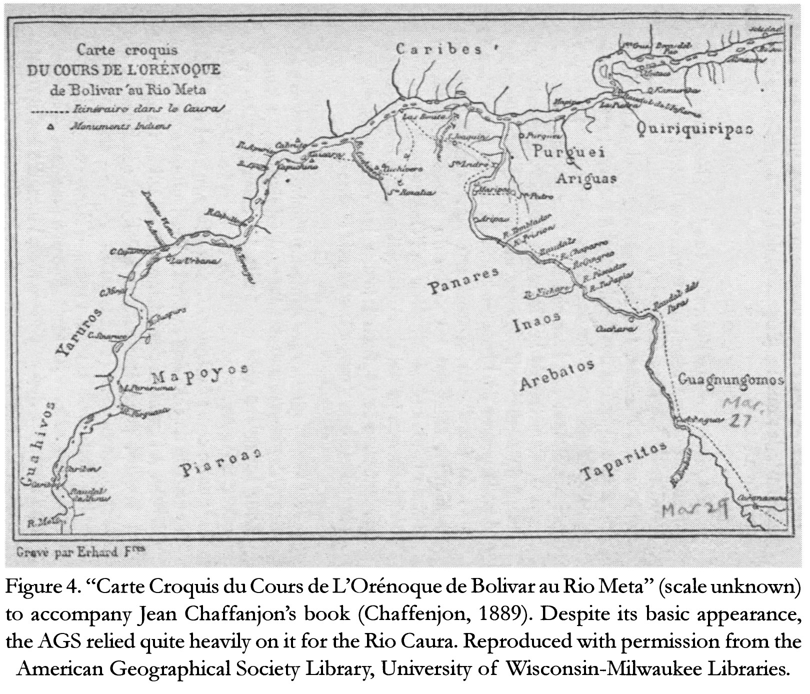
Dispossesions in the Americas

Dispossesions in the Americas

  • Home
  • Explore
  • About
  • Authors
  • Art
  • Bodies
  • Curricula
  • Cultural Heritage
  • Maps
  • Territories
Back to Explore
Map 1884

Carte Croquis DU COURS DE L'ORÉNOQUE de Bolivar àu Rio Meta

  • CHAFFANJON;JEAN

Published: 2015

  • Download Image

Peoples

  • CARIBE
  • QUIRIQUIRIPAS
  • PURGUEI
  • ARIGUAS
  • ENEPA
  • INAOS
  • AREBATOS
  • TAPARITAS
  • GUAGNUNGOMOS
  • YARURO
  • MAPOYO
  • PIAROA
  • JIVI

Citation

Chaffanjon;Jean. "Carte Croquis du Cours de L'Orénoque de Bolivar au Rio Meta." Map. In Revealing the 'Lost World': The American Geographical Society and the Mapping of Roraima during the 1930s;by Alastair Pearson and Michael Heffernan;188. Vol. 14. Journal of Latin American Geography;2015. Accessed March 4;2023. https://www.jstor.org/stable/43964634?seq=19.

  • Download Image

Reading in Spanish

Map 1884

Carte Croquis DU COURS DE L'ORÉNOQUE de Bolivar àu Rio Meta

  • CHAFFANJON;JEAN

Published: 2015

  • Download Image
  • Download Image

Reading in Portuguese

Map 1884

Carte Croquis DU COURS DE L'ORÉNOQUE de Bolivar àu Rio Meta

  • CHAFFANJON;JEAN

Published: 2015

  • Download Image

Peoples

  • CARIBE
  • QUIRIQUIRIPAS
  • PURGUEI
  • ARIGUAS
  • ENEPA
  • INAOS
  • AREBATOS
  • TAPARITAS
  • GUAGNUNGOMOS
  • YARURO
  • MAPOYO
  • PIAROA
  • JIVI

Citation

Chaffanjon;Jean. "Carte Croquis du Cours de L'Orénoque de Bolivar au Rio Meta." Map. In Revealing the 'Lost World': The American Geographical Society and the Mapping of Roraima during the 1930s;by Alastair Pearson and Michael Heffernan;188. Vol. 14. Journal of Latin American Geography;2015. Accessed March 4;2023. https://www.jstor.org/stable/43964634?seq=19.

  • Download Image

Related Content

Geographic Distribution of Huichol and Cora, Showing Towns and Elevations

Geographic Distribution of Huichol and Cora, Showing Towns and Elevations

Map 1969
Carte Réduite Pour la Navegaton de Cayenne a la Martinique. Dressée au Dépost des Cartes Plans et Journaux de la Marine Pour le Service des Vaisseaux du Roy. Par ordre de M. le Duc des Choiseul Colonel Géneral des Suisses et Grisons;Ministre de la Guerre et de la Marine.

Carte Réduite Pour la Navegaton de Cayenne a la Martinique. Dressée au Dépost des Cartes Plans et Journaux de la Marine Pour le Service des Vaisseaux du Roy. Par ordre de M. le Duc des Choiseul Colonel Géneral des Suisses et Grisons;Ministre de la Guerre et de la Marine.

Map 1700 - 1799
PROVINCIE DELLO SPIRITO SANTO E DI PORTO SICURO

PROVINCIE DELLO SPIRITO SANTO E DI PORTO SICURO

Map 1600 - 1699
MUNICIPIOS CON JURISDICCION EN LA SIERRA NEVADA DE SANTA MARIA

MUNICIPIOS CON JURISDICCION EN LA SIERRA NEVADA DE SANTA MARIA

Map 2015
Grupos indígenas de Venezuela

Grupos indígenas de Venezuela

Map 2012
PARAGUAY

PARAGUAY

Map 1878
BORRADOR TOPOGRÁFICO DE LA LÍNEA DIVISORIA, QUE CITA EL ARTÍCULO 12º DEL TRATADO PRELIMINAR, Y AJUSTADAS DISTANCIAS HASTA SU PUNTO FINAL

BORRADOR TOPOGRÁFICO DE LA LÍNEA DIVISORIA, QUE CITA EL ARTÍCULO 12º DEL TRATADO PRELIMINAR, Y AJUSTADAS DISTANCIAS HASTA SU PUNTO FINAL

Map 1800 - 1850
Tohono O’odham Nation Map

Tohono O’odham Nation Map

Map

Dispossessions in the Americas

A project by

University of Pennsylvania

Copyright 2024

With support from

Mellon Foundation

Site design & development

Element 84

Art Credits

Chaffanjon;Jean. “Carte Croquis du Cours de L’Orénoque de Bolivar au Rio Meta.” Map. In Revealing the ‘Lost World’: The American Geographical Society and the Mapping of Roraima during the 1930s;by Alastair Pearson and Michael Heffernan;188. Vol. 14. Journal of Latin American Geography;2015. Accessed March 4;2023. https://www.jstor.org/stable/43964634?seq=19.

Site Pages

  • Home
  • Explore
  • About
  • Authors
  • Art
  • Bodies
  • Curricula
  • Cultural Heritage
  • Maps
  • Territories