Dispossesions in the Americas

Dispossesions in the Americas

  • Home
  • Explore
  • About
  • Authors
  • Art
  • Bodies
  • Curricula
  • Cultural Heritage
  • Maps
  • Territories
Back to Explore
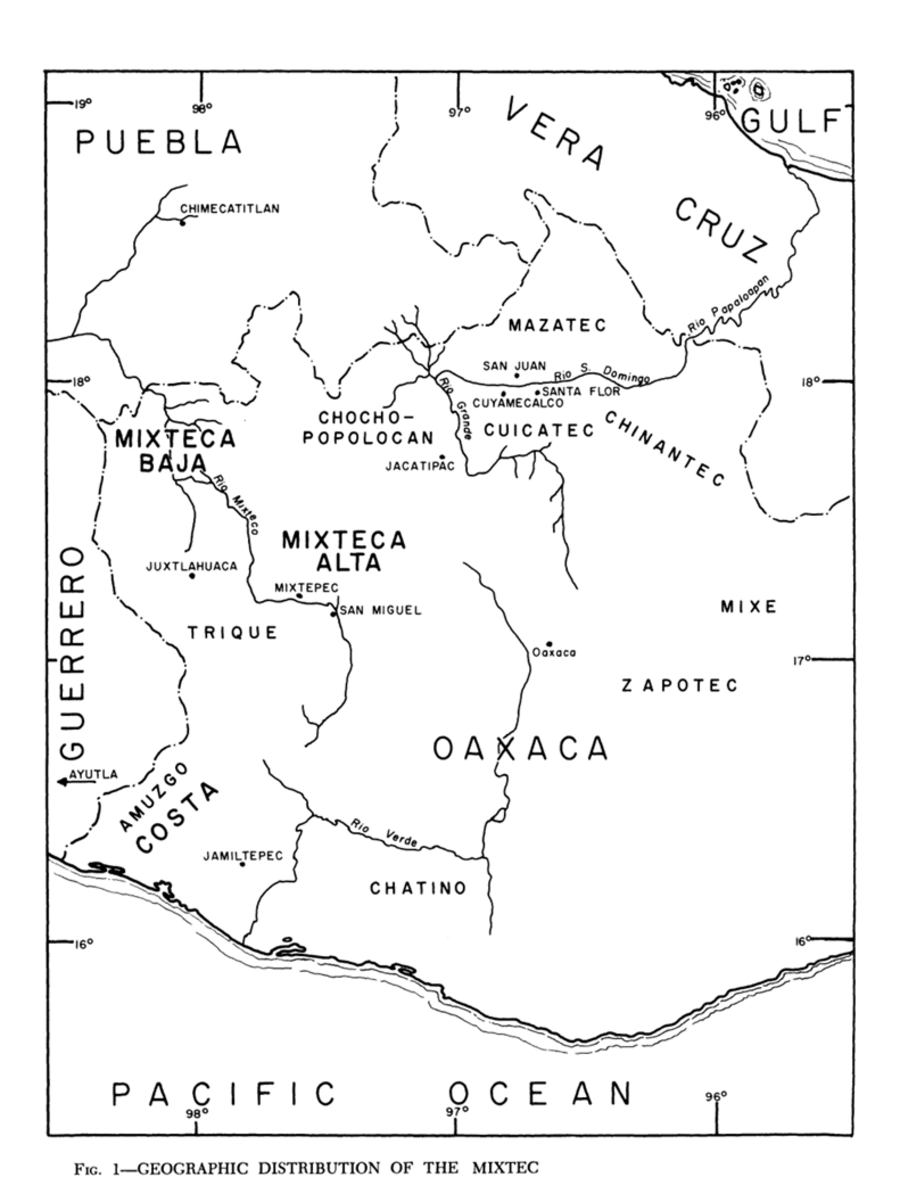
Map 1969

Geographic Distribution of the Mixtec

  • ROBERT RAVICZ, A KIMBALL ROMNEY

Published: 1969

  • Download Image

Peoples

  • CHATINO
  • ZAPOTEC
  • MIXE
  • AMUZGO
  • TRIQUE
  • MIXTECA
  • CHOCHO-POPOLOCAN
  • MAZATEC
  • CUICATEC
  • CHINANTEC

Citation

Ravicz, Robert, and A. Kimball Romney. "The Mixtec." In Ethnology, edited by Robert Wauchope and Evon Z. Vogt, 367. Vols. 7-8 of Handbook of Middle American Indians. Austin: University of Texas Press, 1969. https://ebookcentral-proquest-com.proxy.library.upenn.edu/lib/upenn-ebooks/reader.action?docID=4826335&ppg=383.
  • Download Image

Reading in Spanish

Map 1969

Geographic Distribution of the Mixtec

  • ROBERT RAVICZ, A KIMBALL ROMNEY

Published: 1969

  • Download Image
  • Download Image

Related Content

Carte d'une partie de l'isthme du Darien (Etats-Unis de Colombie) avec le tracé du Canal Interocéanique / par Lucien de Puydt, Ingénieur, Explorateur de l'isthme du Darien

Carte d'une partie de l'isthme du Darien (Etats-Unis de Colombie) avec le tracé du Canal Interocéanique / par Lucien de Puydt, Ingénieur, Explorateur de l'isthme du Darien

Map 1875
Mapa Etno-Histórico do Brasil e Regiões Adjacentes - Adaptado do Mapa de Curt Nimuendajú 1944.

Mapa Etno-Histórico do Brasil e Regiões Adjacentes - Adaptado do Mapa de Curt Nimuendajú 1944.

Map 1400 - 1944
Cróquis del Rio Paraguay y alta Paraná desde el Ivoy hasta un poco más al N. del Rio Jaurú donde se puso el Marco de los límites entre España y Portugal el 14 de Enero de 1753.

Cróquis del Rio Paraguay y alta Paraná desde el Ivoy hasta un poco más al N. del Rio Jaurú donde se puso el Marco de los límites entre España y Portugal el 14 de Enero de 1753.

Map 1750 - 1850
SOUTH AMERICA;BRAZIL;&C.

SOUTH AMERICA;BRAZIL;&C.

Map 1883
MAPA SACADO CON LA OCASION DE LA ENTRADA QUI HIZO Â SU COSTA Â LOS FERTILES Y DILATADOS PAISES DEL GRAN CHACO GUALAMBA

MAPA SACADO CON LA OCASION DE LA ENTRADA QUI HIZO Â SU COSTA Â LOS FERTILES Y DILATADOS PAISES DEL GRAN CHACO GUALAMBA

Map 1774
PUEBLO NAHUA DE PUEBLA

PUEBLO NAHUA DE PUEBLA

Map 2020
Geographical Map of the Republic of Nicaragua.

Geographical Map of the Republic of Nicaragua.

Map 1855
GUARANÍ OCCIDENTAL

GUARANÍ OCCIDENTAL

Map 2015

Dispossessions in the Americas

A project by

University of Pennsylvania

Copyright 2024

With support from

Mellon Foundation

Site design & development

Element 84

Art Credits

Ravicz, Robert, and A. Kimball Romney. “The Mixtec.” In Ethnology, edited by Robert Wauchope and Evon Z. Vogt, 367. Vols. 7-8 of Handbook of Middle American Indians. Austin: University of Texas Press, 1969. https://ebookcentral-proquest-com.proxy.library.upenn.edu/lib/upenn-ebooks/reader.action?docID=4826335&ppg=383.
Site Pages

  • Home
  • Explore
  • About
  • Authors
  • Art
  • Bodies
  • Curricula
  • Cultural Heritage
  • Maps
  • Territories