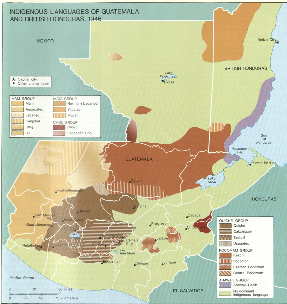
Dispossesions in the Americas

Dispossesions in the Americas

  • Home
  • Explore
  • About
  • Authors
  • Art
  • Bodies
  • Curricula
  • Cultural Heritage
  • Maps
  • Territories
Back to Explore
Map 1946

Indigenous Languages of Guatemala and British Honduras 1946

    Published: 2005

    • Download Image

    Peoples

    • MAM
    • AGUACATEC
    • JACALTEC
    • KANJOBAL
    • CHUJ
    • IXIL
    • MAYA
    • CHORTI
    • LACANDON
    • YUCATEC
    • MOPAN
    • LACANDON CHOL
    • QUICHE
    • CAKCHIQUEL
    • TZUTUJIL
    • USPANTEC
    • KEKCHI
    • POCOMCHI
    • EASTERN POCOMAM
    • CENTRAL POCOMAM

    Citation

    "Indigenous Languages of Guatemala and British Honduras 1946"IN Historical Atlas of Central America by Carolyn Hall and Héctor Pérez Brignoli. PG. 101. University of Oklhoma Press, 2005.

    • Download Image

    Reading in Spanish

    Map 1946

    Indigenous Languages of Guatemala and British Honduras 1946

      Published: 2005

      • Download Image
      • Download Image

      Reading in Portuguese

      Map 1946

      Indigenous Languages of Guatemala and British Honduras 1946

        Published: 2005

        • Download Image

        Peoples

        • MAM
        • AGUACATEC
        • JACALTEC
        • KANJOBAL
        • CHUJ
        • IXIL
        • MAYA
        • CHORTI
        • LACANDON
        • YUCATEC
        • MOPAN
        • LACANDON CHOL
        • QUICHE
        • CAKCHIQUEL
        • TZUTUJIL
        • USPANTEC
        • KEKCHI
        • POCOMCHI
        • EASTERN POCOMAM
        • CENTRAL POCOMAM

        Citation

        "Indigenous Languages of Guatemala and British Honduras 1946"IN Historical Atlas of Central America by Carolyn Hall and Héctor Pérez Brignoli. PG. 101. University of Oklhoma Press, 2005.

        • Download Image

        Related Content

        PROVINCIA DO ESPIRITO SANTO

        PROVINCIA DO ESPIRITO SANTO

        Map 1873
        Map of Nicaragua showing Ulwa settlements in Eastern Nicaragua and field study sites (in rectangle)

        Map of Nicaragua showing Ulwa settlements in Eastern Nicaragua and field study sites (in rectangle)

        Map 1990
        Geographic Distribution of the Chatino

        Geographic Distribution of the Chatino

        Map 1969
        Mapa de costa comprendida entre Trujillo (Honduras) y la desembocadura del río de Matina.

        Mapa de costa comprendida entre Trujillo (Honduras) y la desembocadura del río de Matina.

        Map 1768
        Reducción del territorio Barí 1950 -1970

        Reducción del territorio Barí 1950 -1970

        Map 1950 - 1970
        RELACIÓN GEOGRÁFICA DE SANTIAGO TEJUPAN

        RELACIÓN GEOGRÁFICA DE SANTIAGO TEJUPAN

        Map 1500 - 1599
        Posthumous Self-Portrait of Lorenzo Jaramillo

        Posthumous Self-Portrait of Lorenzo Jaramillo

        Artwork
        ATLAS de VENEZUELA ESTADO ZULIA

        ATLAS de VENEZUELA ESTADO ZULIA

        Map 1916

        Dispossessions in the Americas

        A project by

        University of Pennsylvania

        Copyright 2024

        With support from

        Mellon Foundation

        Site design & development

        Element 84

        Art Credits

        “Indigenous Languages of Guatemala and British Honduras 1946"IN Historical Atlas of Central America by Carolyn Hall and Héctor Pérez Brignoli. PG. 101. University of Oklhoma Press, 2005.

        Site Pages

        • Home
        • Explore
        • About
        • Authors
        • Art
        • Bodies
        • Curricula
        • Cultural Heritage
        • Maps
        • Territories